– Jonathan McDaid, Head of Survey
Traditional highway surveys are expensive and risky. Safety of both the workforce and the public is priority number one when it comes to the planning and design of highway surveys, and in most cases, significant traffic management has to be established – during the day or overnight – to allow surveyors to capture the data required. In some cases, the costs of putting in traffic management and safety measures are more than the cost of the survey itself.
Many contractors are now looking for ways to reduce the risk to their workforce and reduce the costs to the project without compromising the quality of the data. And so they are increasingly turning to mobile mapping services like those delivered by TEXO.
Introducing mobile mapping on highways
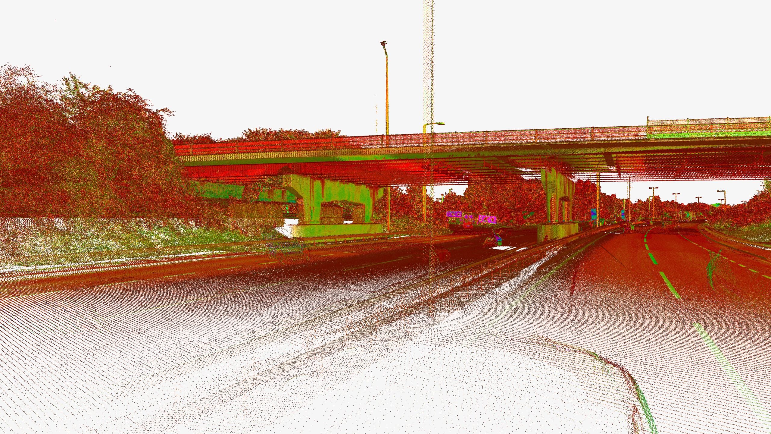
In fact, mobile mapping isn’t a particularly new technology. Survey companies like TEXO have been conducting mobile mapping surveys for highway surveys for many years. Mobile mapping can involve the collection of geospatial data using a variety of sensors from a variety of modes such as cars, boats and even trains. In its most accurate form however, this involves a LiDAR sensor – either mounted on a vehicle, or attached to an unmanned aerial vehicle (UAS) which is flown over the target area – something we specialise in.
Mobile mapping delivers a range of important commercial benefits to projects at all levels and our clients often reference the following:
Reduced costs – by reducing and sometimes even removing the need for complex traffic management, mobile mapping delivers a much more cost-effective survey option, especially for long stretches of highway
Improved health and safety – by significantly reducing the need for personnel on the highway – from the surveyors themselves to the teams that manage traffic restrictions – mobile mapping contributes to better project safety results
Precise data capture – mobile LiDAR mapping offers outstanding data quality, and billions of data points can be captured and subsequently modelled in the way that suits the contractor best – 2D, 3D and interactive – allowing for better decision making and faster project progress. At TEXO, this data is made available through our collaborative portal, Texzone, where multiple teams can access and interrogate the data quickly and seamlessly
Reduced carbon emissions – by not disrupting the efficient flow of traffic on the highway, and by significantly reducing the number of workforce vehicles needed on the road to complete a traditional survey, contractors can measurably reduce the carbon emissions associated with their project – now something that’s often an outcome target on many highways projects.
“The beauty of mobile mapping is that we can carry it out at any time to suit the client,” says Jonathan McDaid, Head of Survey at TEXO. “The vehicle-mounted LiDAR can be used in normal traffic conditions, driving at road speed where necessary, and still capture high quality data. Where a UAS solution is required, we can plan that outside of heavy traffic hours and our highly-trained pilots can fly accurately and safely at any time of day or night with a flight plan that is tailored to a clients brief.”
Mobile mapping in action
TEXO was asked to help with the details survey of a 50-acre disused quarry site in Kent, on behalf of developers. With steep embankments and a busy road network surrounding it, the client needed mobile mapping to collect key data safely without having to put its workforce in a potentially dangerous situation.
Vehicle mobile mapping – using our industry leading LiDAR system, we successfully mapped the live roadways within and bordering the site, with no need for costly traffic management. Ground control was installed safely on the footpaths to verify the LiDAR data. This brought a huge benefit for our client in terms of safety and efficiency.
UAS mobile mapping – by deploying our UAS LiDAR system, we guaranteed accurate ground surface levels through even the densest vegetation. This enabled a detailed ground surface model, and contour plot to be developed. It also reduced the time on site and potential safety issues by capturing data in ‘live’ construction areas.
You can also watch a short video on mobile mapping here.
Contractors can choose to use this survey method for a variety of highway-related projects, including carriageway, bridge repairs and embankments, as well as the land around the current network, which is particularly important for road extension or widening schemes, as well as for planned developments alongside existing highways.
“This type of survey is popular with our clients for obvious reasons,” says Jonathan. “We can show them that they don’t need to put boots on the ground, and that we can significantly reduce the time it takes to produce quality survey data. For some projects, a traditional approach can take several months, but using mobile mapping brings it down to just two or three days – that represents an exceptional saving in cost and time, and we know how important that is to contractors who are running on tight budgets and timescales.”
“Of course,” adds Jonathan, “there will always be a need for people to be on the highway. Often, we will need confirmation of something that’s come up on a survey. For example, is the chamber that we have mapped from LiDAR data we surveyed a gas chamber or a telecoms chamber? Or an object that has been obscured from the view of the scanner? The difference is that surveyors can be deployed strategically to the areas in question, rather than taking the time and expense of shutting large parts of roadway down. So mobile mapping takes away a significant portion of the risk on these projects – clients can do a safe, cost-effective initial survey that captures highly accurate geospatial data and plan for a workforce presence on the highway in specific areas or to confirm and enhance essential details.”
To find out more about how we can deliver a mobile mapping survey for your highways project, contact us today: info@texo.co.uk